A Look Deep Inside the History of Cornwall’s Most Recent Engine House Conversion
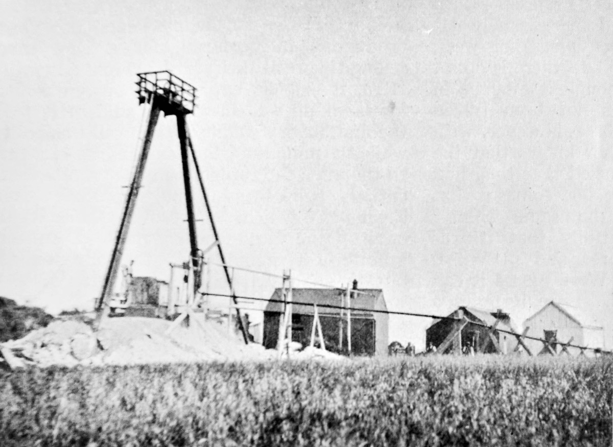
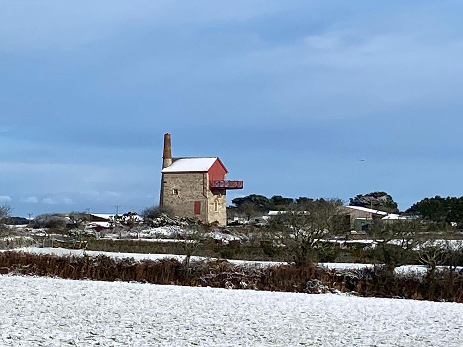
Adjacent to the Helston-Falmouth road is probably one of Cornwall’s most prominent engine houses. Beginning in 2019, it underwent conversion from a state of near collapse and now, in 2021, it finally reached its refurbished state. It is probable that more people glimpse this relic of Victorian Cornwall up close than any other in the county. So, using archival research and historic mapping, what can be learn of this monument to Cornish Tin Mining today?
Origins of East Wheal Lovell Mine
Historically speaking, you might hear the names Tregonebris, Carnebone, Fatwork discussed as well as the likes of Wheal Duchy and such like. Research has shown that these don't all mean the same mine or even a reference to different periods of activity; instead, they simply relate to a broad series of workings in the general area throughout the preceding centuries. Whilst most certainly ancient, the district has also has seen its prominence mature with age.
Since late medieval times, the village and parish of Constantine – situated only 2.5 miles from the Lovell mines – played support to this vibrant mining community, and operated its own blowing house and port which later became the dispatch of choice for tinners in the district. John Norden (c1586) on his travels described it as:
"A parishe standinge on a hill, and in and nere it manie Tynn Works"
And went on then describe Wendron, the neighbouring parish and in which our mine is situate, as:
"In this parish are the beste tynn-workes, as Roselyn, Garlimoe, Portkellis, and others."
One can't help but wonder whether these descriptions, when considered in tandem, indicate workings in the locality of East Lovell prior to any surviving records.
Apocryphal as this may be, it is certainly true that Wendron itself is one of the most fascinating parishes in the county. Indeed, it has been the site of many mining firsts, for example; the first water-powered stamping mill in the world at Trenear Wollas in 1493, and what is thought to be the first mining sett in 1574 for what we know as Balreeth or Halwyn.
With this borne in mind, is it a stretch to imagine that it was not Wheal Vor but instead in this parish, at Balcoath – the mine opened by the adit of the above sett – that the first Newcomen steam engine in Cornwall was put to work? It will remain superstition in light of no conclusive sources, but as far as rumours go, one might be tempted to hedge their bets.
In Elizabethan times, the hundred of Penwith was surveyed for its tin works and the parishes of St Just and Wendron compared in this capacity. The latter was noted as having:
"From ancient times paid the greatest amount of 'Tribulage' within the Stannary"
Now, we all have heard of the Tin Coast, but St Just's importance at this time seems to have been overshadowed by the forgotten riches of a few fields and boggy marshes of the Porkellis Moors at the back of Helston. Make of this what you will, but leaving the realms of speculation, the first direct reference to mining in what we now know as East Lovell comes to us in 1676 when "Carnebyn Bounds" are recorded in a document in the Cornish Archives.
Carnebyn or Carnebin likely translates to "Little Carn", whereas Carnebone could translate differently, maybe to "House on the Hill" indicating that initially, when mining at this time commenced, there were no permanent inhabitants. If we're talking chicken and egg, maybe the mines came before the people?
The first references to 'Carnebone' in its present spelling can be found Grylls Estate collection at the Cornish Archives, and dates to the late 18th century. At this time, it seems to have been the case that Carnebone was simply a dwelling house and a couple of meadows; the tenement being described as bounded on the east by the Turnpike road (now the A394) and on the west by Constantine parish. Thomas Martyn's map of 1748 shows all the tenements in the area at this time and distinguishes between those with and without dwellings, for those who are interested.
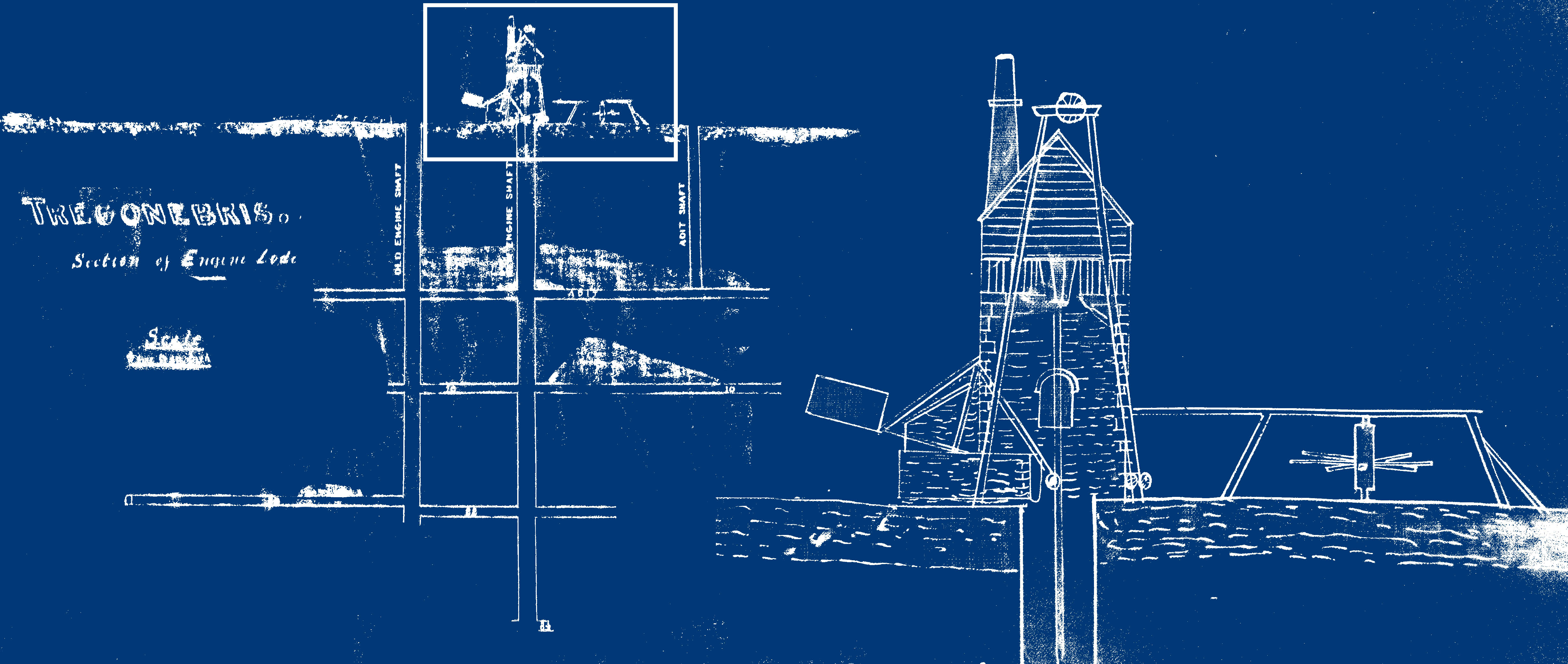
There is a big gap in the history of mining on the site until the 1790s. Here, and then under the name of "Tregonebris", the mine was first tried with use of a steam pumping engine. Simultaneously to this, and not otherwise recorded, the site to the east of the road and NE of the engine house we see today, a separate mine or portion of the described was at work, pumping by means of a waterwheel (the leat for which originated at lower Retanna) and rag & chain pump.
The likes of these primitive devices were discovered when the mine was dewatered in the 1853 rework and a description published in the Mining Journal of that year.
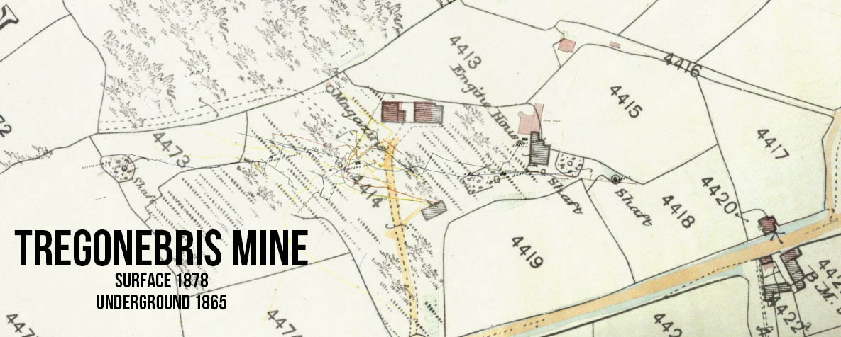
The remains of the mine from this period can be clearly traced with a look at historic Ordnance Survey mapping and some liberal inference. At this point, the part of the workings on the west side of the main road were known as "Tregonebris" (the section where our engine house conversion is today) and the east side of the road as "Fatwork". The lack of strict adherence to place names plagued the entirety of the Lovell group of mines as many an historian has found out, and East Lovell is just another of these rabbit holes.
East Wheal Lovell is Born
Stannary Court records detail the first reference to works under the title of "East Lovell" in 1857, it previously (1853-5) having been worked under the name of Tregonebris & Carnebone Fatwork Mines. From a first-hand description of the mining then done by the company through local historian Richard Cunnack, it can be inferred that the two named companies were different iterations of the same entity as the mine was at work throughout this period.
Initially calls were made after long delays while clearing old workings, however eventually the bottom of the old shaft was reached. Management persevered with sinking below the then bottom of 40 fathoms in depth (~70m) and by 60 fathoms, a rich deposit of ore had been found. The mine was propelled into a dividending state for the first time in 1863 and was to remain so for another 11 yrs.
This brief period of prosperity prompted the creation of many spin-off ventures. Styled in a familiar lexicon and with hopes of garnering investment by association, these held names such as "Great East Wheal Lovell" and "New Wheal Lovell". This "black gold rush" spurred on the draughting of large-scale maps of the mining district by the likes of Brenton Symons and J Ridington in the 1860s and 1870s.
However, it is a perilous exercise to prophesize greatness, and naming your mine "great" before it has worked its first pitch sets a dangerous precedent. It soon became apparent that the East Lovell spin-offs were never to return a consistent profit, and our mine, having received multiple calls for investment, finally entered entered insolvency.
Throughout its dividending period, the Tregonebris section of the sett was known as "East Wheal Lovell" – working North & South lodes, whereas the Fatwork section (where the surviving engine house being offered for sale lays) was known as "Old East Lovell" or "Wheal Duchy" indicating the mineral ownership.
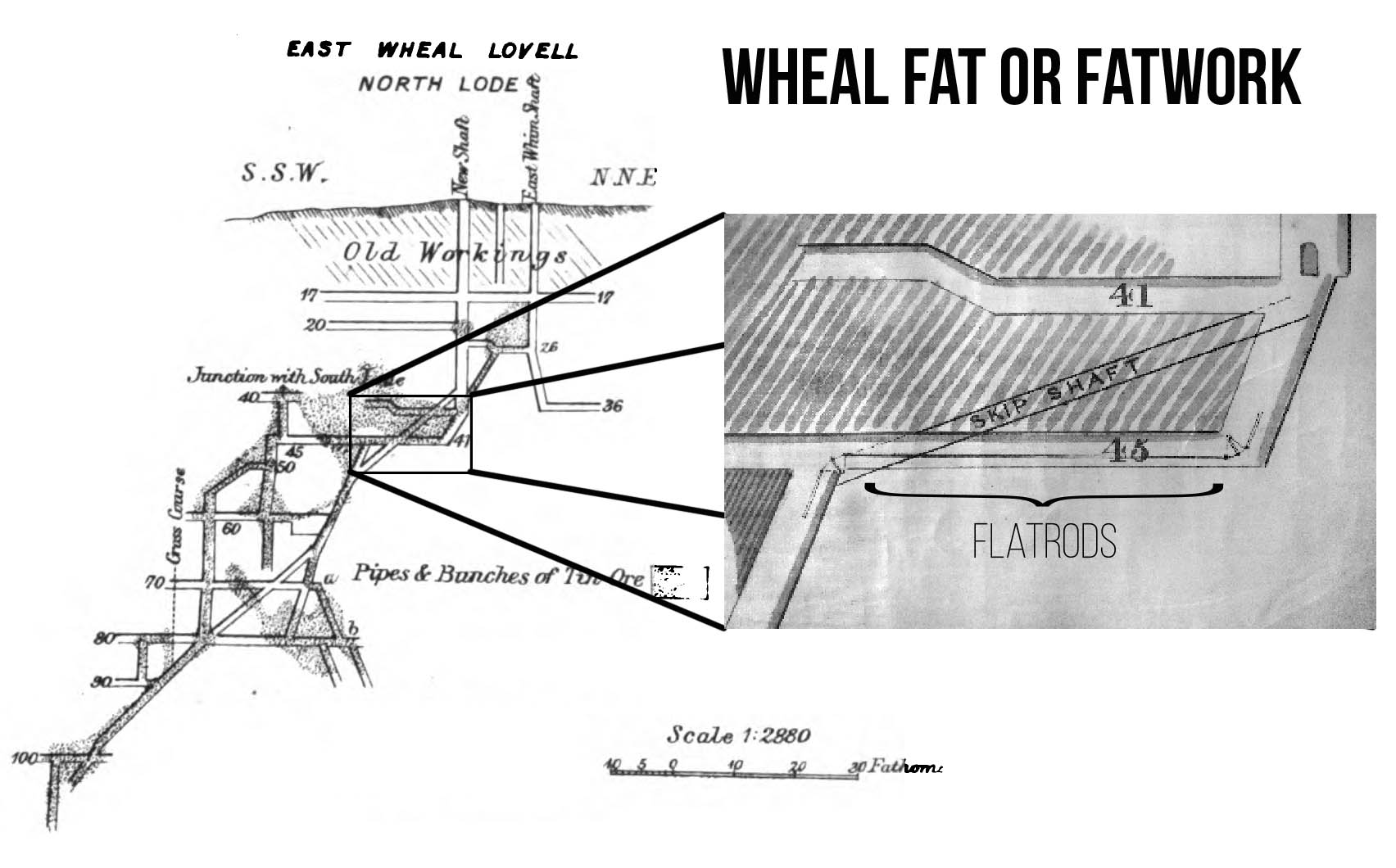
The mineral lodes of the district east of Porkellis were characteristic for their irregular geometry; as opposed Cornish standard of high angle veins. These deposits were known interchangeably as "Tubes", "Chimneys", "Shoots" or “Pipes” and are still used as geological case studies in textbooks today. From the discovery of ore at 60 fathoms, the shoot was chased (- a fantastic contemporary choice of verb) progressively deeper.
Naturally, no foresight was employed in the sinking of shafts or the safe maintenance of secure capital, and all shaft sinking was carried out on the outcrop or “gossan” of the lode. These were decisions that proved fatal for many a big mine elsewhere (such as at Levant), but was simply the natural approach in the Lovell district.
Returns were always immediate as the rock excavated was also ore and could be sold to cover the expenses of working, however the irregular course of the shaft made development successively harder. The mine plans dated 1874 (R144A sheet 8) show the extent of the contorted workings after having sunk to a terminal depth of 110 fathoms along the shoot of ore.
It also depicts the numerous balance bobs employed for the changes of direction of the pump rod; and above this chaos is shown blocked-out ground right to surface labelled as "OLD WORKINGS" – likely in reference to the late 18th century venture. To crystallise this connection to these previous workings, adjacent the engine or 'sump' shaft is recorded "Wheel Pit Shaft" – clearly describing the rag & chain pumping shaft found in 1853.
The Decline of East Wheal Lovell Mine
A mine, however prosperous, will always be at risk of exhausting the deposit; or perhaps, even more likely, will face economic obliteration through a collapse of metal prices. East Lovell was a rare case amongst Cornish mines as it owed its downfall not to low tin prices but rather the complete exhaustion of the deposit! At 90fms (30fm below the discovery of the shoot) in depth the rich tin was said to disappear, a mass of Gilbertite or Prian occupying its whole width instead.
Come 1874, the ground had been entirely worked out and the last dividend paid; abandonment plans were produced, the workings in the Tregonebris portion of the sett – centred around SW 1704 3172 – being discontinued for the last time in 1875. The site, with its dual engines; pumping, winding & stamping, was surveyed by the Ordnance survey shortly after abandonment in 1877 and the shaft names recorded. Viewing this with eyes of the 21st century is perhaps the last window back into 1795 one might hope to achieve for the mine, and is certainly its most ancient traceable remains accurately recorded.
The company, not yet content with winding up operations having remained profitable until recently, had removed an engine from the Tregonebris section to work a new shaft a little south of the Turnpike Road. The site is shown as early as 1870, and remains today being traceable as an overgrown spoil heap adjacent a farm track (SW 7015 3146). This paid for a time while the northern section was neglected, but even this too became exhausted after sinking 35 fathoms.
In a final bid to secure the future of the mine, an engine was bought from the swindling Great East Lovell and "put up on Roger's Shaft" (named after the then manager of the mine); a cursory look at the mine plans (R144A sheet 11) shows the site of Roger's Shaft to be 100yrds distant to the SE of the present engine house.
It stands to reason then, in absence of a section on these Fatwork workings, that the engine was a combined pumping and winding in purpose. This appears to have have supporting evidence, as there does appear to be remains of winding drum and flywheel supports on the SE side of the engine house. It's also entirely possible that the once-off reference to the engine being placed on Roger's shaft is just a misquotation back in the days of quills and ink blots. Who can say.
The mine never returned a profit during its last 6yrs: a final set of abandonment plans for the Fatwork portion were produced deposited at the Mining Records Office, appending onto the collection; "A.M. R144" as sheet 11. The mine ceased work and petitioned for dissolution two years later in 1883, thus ending an unlikely success story in a time of scams and bad luck. It paid the last divided of the Wendron mines, a phenomenal feat considering the challenge posed by the geology at hand: they say the rock drill never made their way into the Wendron mines.
Let the impressive remains of the engine house stand as a reminder to the endeavours of hard-working families throughout a time without social benefits, central heating or flushing conveniences. But do remember before turning your local mineshafts into unofficial landfills, that the mine is not the surface but rather the tunnels that remain hidden and untouched beneath the grass we live our daily lives above.
New Wheal Lovell?
In 1927, once again there was a buzz of activity in the area as a company was at work under the namesake of "East Wheal Lovell". Work was however restricted to a pre-existing shaft 300yrds east of Laity, this being outside the historic sett of the previous workings under the same name. In 1869, this was known "New Wheal Lovell East Shaft", it being the eastern most shaft and near the sett boundary of New Wheal Lovell mine at the time, however before 1875 it had come to be known as Colonel's. Whom this was coined after is unclear.
Work done between 1927-8 was limited to clearing up old workings and prospecting on account of the Anglo Oriental Corporation. It is reported that a new lode was discovered during this period, a new shaft – Reed's – was sunk on this lode and a 20ft level driven, but no work besides this. Abandonment plans dating 1928 were produced and deposited in the home office.
And thus concludes the last operations in the Wendron mining district south of the Porkellis area.
Post-mortem it was reported that pitchblende was discovered in depth in the East Lovell mine, however while it is possible the area is residually 'hot' due to decomposition of granite into radon, this was likely just an investment ploy to 'job' the mine into reworking, and thus supplying the area with temporary work.
